

Baxter State Park in June
As is our annual ritual (mostly???), Tammy and I went back to BSP June 17 – 20. I wanted to get in to Chimney Pond during the longest days of the year. During the Summer Solstice, the sunrise points more directly into the Chimney Pond basin than at any other time of year and I thought it might be a good opportunity for sunrise pictures of the basin and mountain. We made reservations well in advance for a night at Chimney Pond, a night at Davis Pond and a final night back at Chimney Pond.
Day One – Chimney Pond
As always we were excited to get on the road and not be working on a Friday. We arrived at the BSP gate house before 10:00 AM and were on the trail at Roaring Brook Campground by 10:30. The hike from Roaring Brook Campground to Chimney Pond is a bit less than 3.5 miles and is pretty easy. Arriving at Chimney Pond by early afternoon, we found our assigned lean-to, unpacked, and ate lunch. The afternoon of day one was spent scouting morning photo locations, washing up, and getting our gear in order.
One potential plan was to do the classic circuit of the Knife’s Edge on our last day back at Chimney Pond. This route is typically hiked either up Cathedral Trail, over the Knife’s Edge, and down the Dudley Trail, or vice versa. Unfortunately there had been a land slide on the Dudley Trail over the winter/spring and it will be closed until 2018. This makes a day trip over the Knife’s Edge with Chimney Pond as the start/end impossible.
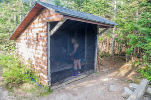
We found the black flies to be pretty bad this year, but we planned ahead and brought a no-see-um screen cloth that fit pretty well over the front of the lean-to. Some flies still got in, but it was livable. It would have been hell without the screening.
Day Two – Davis Pond
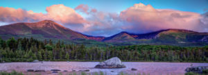
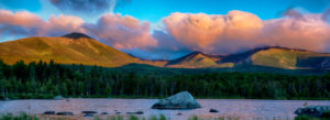
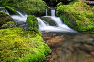
The next morning I was up before dawn and headed for the Chimney Pond outlet for pictures of the pond and mountain. Black flies were, once again, annoying, but not terrible. I was able to get in a few shots just before sunrise and a few with Baxter in the sun. Below are the two best.
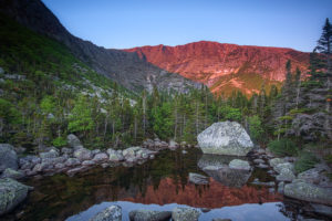
.5 sec @ f 8.0 12mm ISO 100
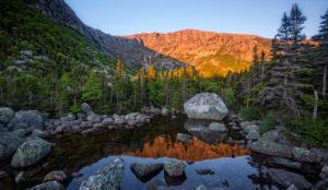
1.0 sec @ f 13 10 mm ISO 100
I woke Tam up after sunrise and had our standard breakfast of instant oatmeal, pop tarts, and coffee. We packed up and headed out for the Saddle Trail to the saddle between Baxter and Hamlin peaks. Going was slow with full packs, but the morning temperature was good and the bugs weren’t bad while we were moving. After an hour or so, we reached the top of the saddle and headed off for the North West Plateau. This section of trail has a bit of boulder scrambling, but isn’t difficult. In about a mile we reached Caribou Spring at the junction of the Hamlin Ridge and Howe Peak trails. The spring was running steady, but not as fast as I have seen in the past. I’m always amazed at the power of water pressure and how there can possible be flowing springs on mountain tops. We continued on the North West Plateau Trail and headed down to Davis Pond. We had come here in October of 2013. It was a wet Fall and the trail had fully flowing stream running down it. I said I would never come back, not only due to the trail conditions and steepness getting off the North West Plateau, but the trail from Davis Pond to Russell Pond was a slog in boggy water up to your knees. Well, we came back, but were not heading all the way to Russell Pond on this trip. As on our prior trip, there was running water in most of the trail and the last half mile or so was steep, steep, steep. It was daunting to think we would have to come back up this the next morning.
We made it to the Davis Pond lean-to in the early afternoon, dumped our gear, and immediately went to the pond to wash off the sweat and grim. There was a waterfall flowing down the back wall of the basin last time we were here and I was not sure if it flowed year ’round. It did not disappoint as it was fully flowing this day also. I wanted to go explore near it, but it was a long scramble away and unfortunately the black flies were horrendous. My original plan was to explore the larger Lake Cowles further down into the basin, but the black flies crapped on this plan too. We got back to the lean-to ASAP, put up the bug screen, and spent the rest of the day in relative comfort.
The next morning I, once again, got up before sunrise to snap a couple shots of the waterfall. We then ate our standard breakfast, packed up, and began our journey back to Chimney Pond.
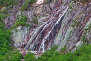
1.5 sec @ f13 150mm ISO 50
Day Three – Back to Chimney Pond
Back the way we came to the North West Plateau. It was steep, steep, steep, again (obviously), but we took our time and it really wasn’t that bad. The wind was brisk on the plateau and we settled in behind some boulders to eat a quick snack. At this point we decided that we didn’t want to go back down the Saddle Trail with full packs as there is a lot of loose, granite sand. It is a landslid after all. Our final plan was to hike a bit longer to Hamlin Peak and go down the Hamlin Ridge Trail back to Chimney Pond.
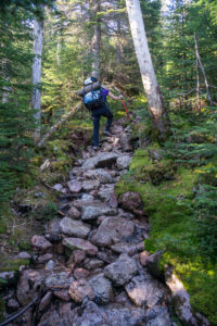
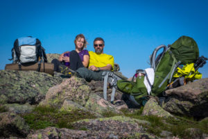
We met a family on Hamlin Peak that were picking off the New England 4000 footers. We exchanged taking pictures for one another and off we went in opposite directions. We did the entire circuit of Hamlin, Baxter, and Pamola peaks in June of 2014. On that trip we ascended the Hamlin Ridge Trail with day packs. Today we were descending with full packs. It is a beautiful trail and I was able to appreciate it for the first half mile or so. After that we both just wanted to get to the bottom. Lots of ledge and boulder scrambling made for a difficult day with full packs, but we finally made our way back to Chimney Pond for our last night.
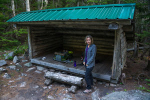
Below are some photos of our trip in June 2014
Jessechan
31 Oct 2016Amazing pictures
Hannah Moreau
26 May 2021Hey there. Was curious what size bug screen you brought for the chimney pond lean to? I am camping at chimney pond at the end of June and it does not seem like my backpacking tent and another’s will fit so thinking a bug screen may be the way to go.
Keith Corson
7 Jun 2021Hannah,
The park frowns upon putting tents up in a lean-to, but anyhow….
The bug screen we made is approximately 8′ X 10′. We hold it on the front with push pins and works great. I’ll reply directly to your email also.
Keith