As I stated in one of previous posts, I had intended on hiking Little Bigelow mountain in western Maine a couple of weeks ago to capture the full moon, but with temperatures dropping into the negative numbers and windy conditions that evening, the hike was called off. Well, Tammy and I made the trek during the day last Saturday, Feb. 2. It was a nice, sunny, blue sky day when we set out from my folks place in Strong. We drove to N. New Portland and up through Lexington to the East Flagstaff Road, which provides access to the Eastern side of the Bigelow Preserve. We reached the intersection with the Appalachian trail shortly after and checked the snow conditions. Not much of it and what was left was pretty dense and solid. No need for snowshoes today. This is a pretty popular winter hike and the trail was packed pretty nicely from previous snowshoers. We slipped on our Kahtoola micro spikes, put enough layers on to stay warm (not too warm) while hiking, grabbed our gear and set off for the summit.
From the East Flagstaff Road intersection with the Appalachian trail to the summit of Little Bigelow is 3.0 miles. The first 1.4 miles was very gradual and follows a small stream. At the 1.4 mile mark is a side trail leading to the Little Bigelow lean to. I’ve stayed here many times over the years, the most recent being last summer with my niece as we ended our north bound hike over the Bigelow range. One time I spent the night here I came face to face with a moose in the middle of the night while taking care of some ‘business’! The stream at the lean to cascades into very narrow, deep pools called the “Tubs”. Even in the middle of August, the water here is cold enough to give you a head ache. Today the water was flowing over ice cascades. Very nice…. We stopped for a quick bite and continued on.
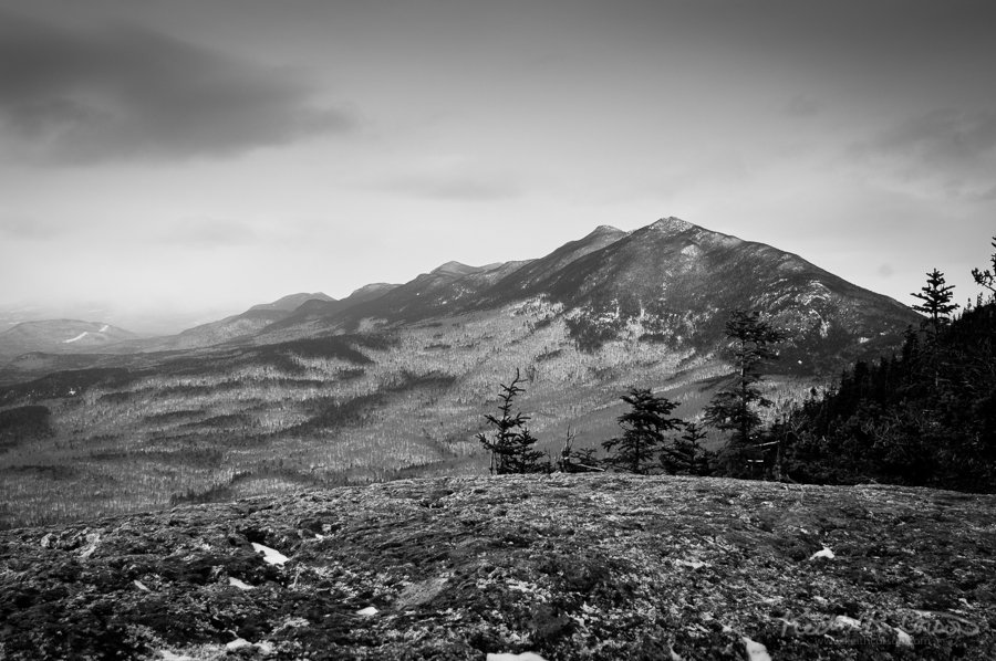
From this point, the trail gets steeper, but not too steep. It seems fairly short as there are multiple ledges on the ascent providing view points as you increase elevation. The views helped to keep my motivation up. Much better than slogging through the snow in the woods all day. When we finally reached the summit (3,040 ft.) the sky had changed from blue to cloudy gray with the threat of snow showers. This summit provides an awesome perspective of Carrabassett Valley with Sugarloaf to the West and the Bigelow range to the North. As you summit, you come out of the evergreens and approach the back side of a huge cliff dropping off into the valley. As you reach the top of the cliff, the valley just opens up in front of you. Breathtaking! We summited at shortly after 2:00 PM, immediately put on all of the layers that we had packed with us and donned our warmer hats and mittens. It was in the single digits with a light breeze. Not too chilly, but it did work into your bones if you didn’t move around. I really wanted to stay at the summit until sunset, but with the weather conditions it didn’t look like we would get much of a show. Took some B&W pix and headed back to the warm truck! Round trip: 6 miles. Time: appx. 4 leisurely hours.