Taughannock Falls State Park is located on the West shore of Lake Cayuga near the small town of Trumansburg, NY. The name Taughannock comes from the Algonquian-speaking Lenni Lenape (Delaware) Indians, referring either to chief Taughannock or the word taghkanic (great fall in the woods).[1] The main drop is 215 feet high, making it 33 feet higher than Niagara Falls and is among some of the highest East of the Rockies.
I stayed at the State Park campground from Wednesday, May 8 – Sunday, May 12. I arrived early in the evening to find that I was the only camper in the tenting area. There was one RV in that portion of the campground, but I was all alone and had the bathroom/shower all to myself! It was early in the season and the masses hadn’t begun their Spring outdoor adventures yet. No complaints from me. The weather for the time I was there was supposed to be unsettled, but I lucked out and only got stuck hiking in the rain for an hour or so one morning, otherwise I stayed dry. The last night of my stay, a threesome from Pennsylvania moved in right next to me (out of the whole tenting area, why next to me?). Without getting into details, I’ve determined that it doesn’t matter where you are from, rednecks are rednecks ;-).
There is a nice trail around the North and South rim of the gorge that is about 2 1/2 miles total. The campground is directly on the North Rim Trail adjacent to the lower falls. I hiked this trail my first evening at the park.
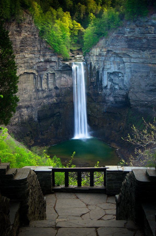
The above photo was captured at the observation deck on the North Rim trail. I chose to walk the trail, but you can drive to this spot. I was lucky enough to be here in the evening while it was misting, so there were not many other people. With some patience I captured the deck while no one was around. There is some light editing with Lightroom 4. Graduated ND filter above the falls, some saturation of the pool below the falls, brightening of the white falls, and darkening of the observation platform.
.8 sec @ f 14, ISO 100, 35mm
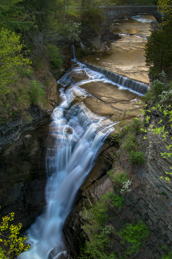
The above photo is of the Upper Falls taken on a bridge linking the North and South rim trail. I used a Singh-Ray Gold-N-Blue polarizer to capture the yellow/gold of the water reflections. The stone bridge at the top of the photo is a regular traffic bridge on the main highway above the State Park. Once again, some light editing to tone down the highlights, but bring out the details in the shadows.
1.6 sec @ f 14, ISO 100, 18 mm
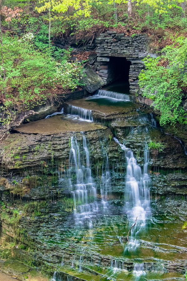
This spot is to the left and upstream from the Upper Falls. I had read about this little side stream entering the main river near the traffic bridge at the top of the State Park. What I had read didn’t give a specific location, so I’m glad I found it. This is an HDR composite of 3 bracketed shots .5 sec, .8 sec, and 1 sec @ f 8, ISO 100, 40 mm. As always, when using a tripod for bracketed shots, I turn off image stabilization and I focus manually. I use an HDR plugin for Lightroom from Photomatix.
There is also a level, easy walking path through the gorge that will bring you to the base of the falls and an observation deck. It’s about 3/4 mile one way. It follows the river and really gives a perspective of the depth of the gorge. Much of the river flows over hard, flat limestone, which is riddled with small pools and ripples. I’m amazed that some of the area literature still claims that the ripples are from beach waves that hardened over millenia. This was disproven long ago. They are the result of chemical erosion. It works something like this: Limestone is made from calcium carbonate. Rain as it falls collects a small amount of carbon dioxide from the air producing a weak carbon acid that calcium carbonate is vulnerable to. Over time this creates puddles, ripples, and in many cases caves and potholes. Enough Mr. Science. It’s just that I’m surprised that the wrong information is still out there… even in some of the Park literature. Should I be??
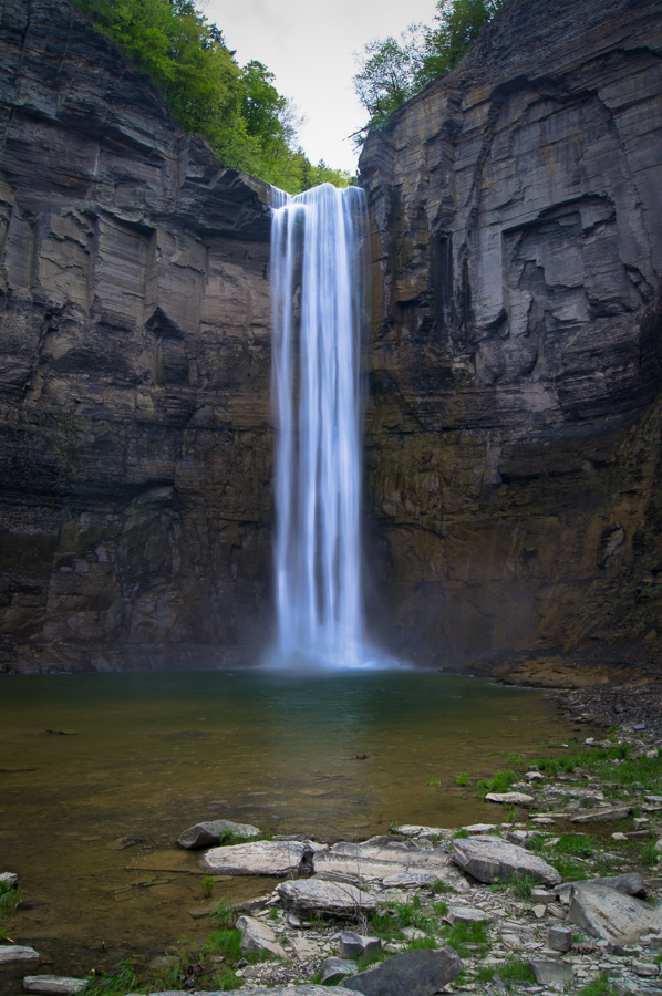
View of the base of the main drop from the stream bed. Very little post processing.
.4 sec @ f 8, ISO 100, 20 mm