The Potholes – Greenwood – Revisited
A had some vacation time to use on the first week of October so I went back to the Potholes in Greenwood, Maine. I had explored this area this past spring with the vow to come back and explore in more detail.
Getting There
Pasted below are the directions that I gave in my original post from June 6, 2013
“To reach the potholes you have to walk an active railroad for a couple of miles, which is illegal, so kids don’t try this at home… yadda, yadda, yadda…. You can probably reach them via a North or South entry, but a colleague showed me how to approach via the South. Drive to West Paris on route 219 and continue toward Greenwood. The Little Androscoggin River parallels the road on the right. Route 219 crosses over the Little Androscogging then veers left where Old County Road continues straight. Stay on 219 here. Shortly after the left at Old County Road, the railroad comes in high above the road on the right and there is parking on either side of the road. As a second option, you can travel 100 yards or so further and park where Route 219 crosses the river again at a little spot on the right. If you choose the second option, there is an old trail on the left side of the river heading upstream. In either case, once you reach the railroad walk North. Cross a stone trestle where if time permits there is a path leading along the river back to route 219. Nice falls here! I explored this area on my return. Shortly after the stone trestle you can hear water rushing to the right side of the railroad. There are a great bunch of boulder falls located here. I also explored here on my return. At 1.25 to 1.5 miles cross a steel trestle. This can be creepy if you are afraid of heights. At approximately 1.75 miles there is an old, round, cement tile to the left of the railroad. Enter the woods here and walk straight on to the potholes.”
I’ve been using this Google app on my Android phone called My Tracks to track my hikes via GPS. Once a track is completed I can automatically upload it to Google Maps for later reference. Here is the resulting map from this treck:
View Potholes in a larger map
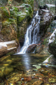
At the Potholes
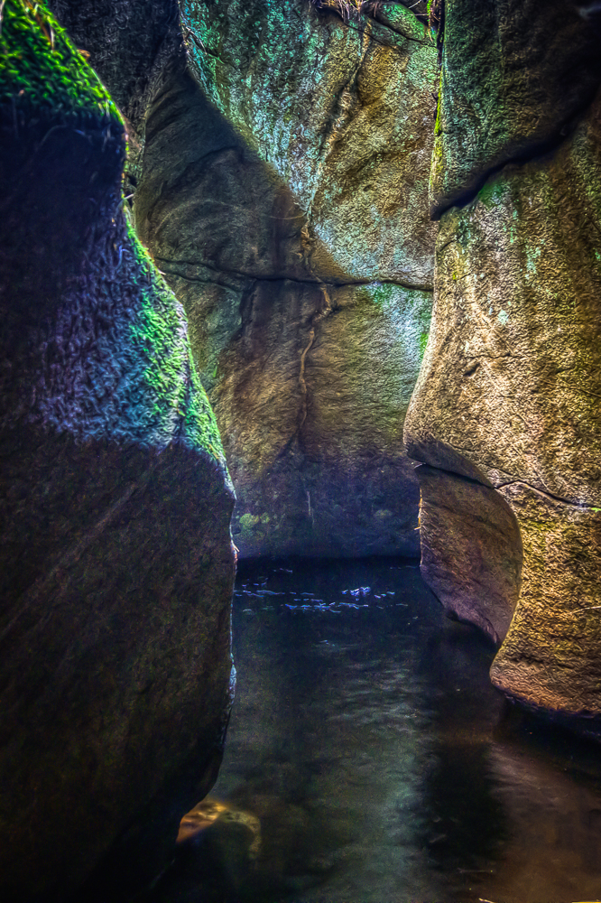
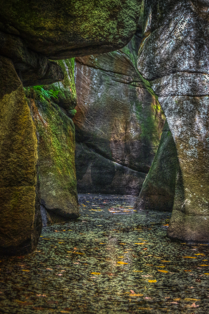
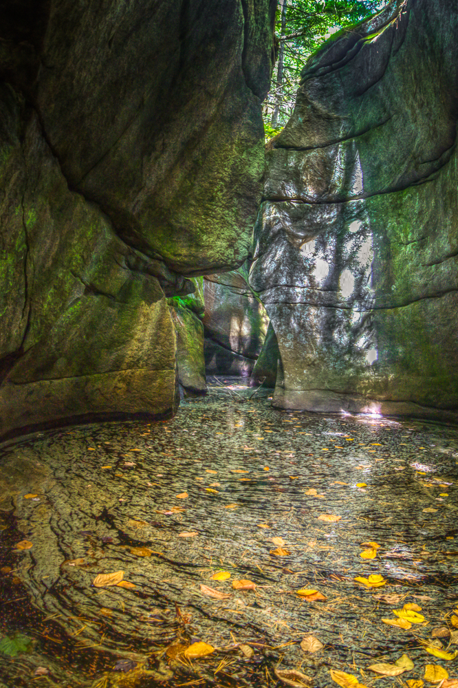
During my initial exploration here this past spring I was not equipped to explore where the river had eroded the rock over eons to form deep chasms. I was back here just for that purpose. I had chest waders and rubber boots in my pack so I could get down into the chasms without getting wet. I remember the last time I was here the deep, dark, pools in the chasms gave me the creeps. You couldn’t see the bottom of some of the pools so there was no telling how deep they were or what had accumulated on the bottom…. carcasses, gnarled tree limbs, algae? I wasn’t excited about doing this even in waders…. overactive imagination I guess… you get the idea.
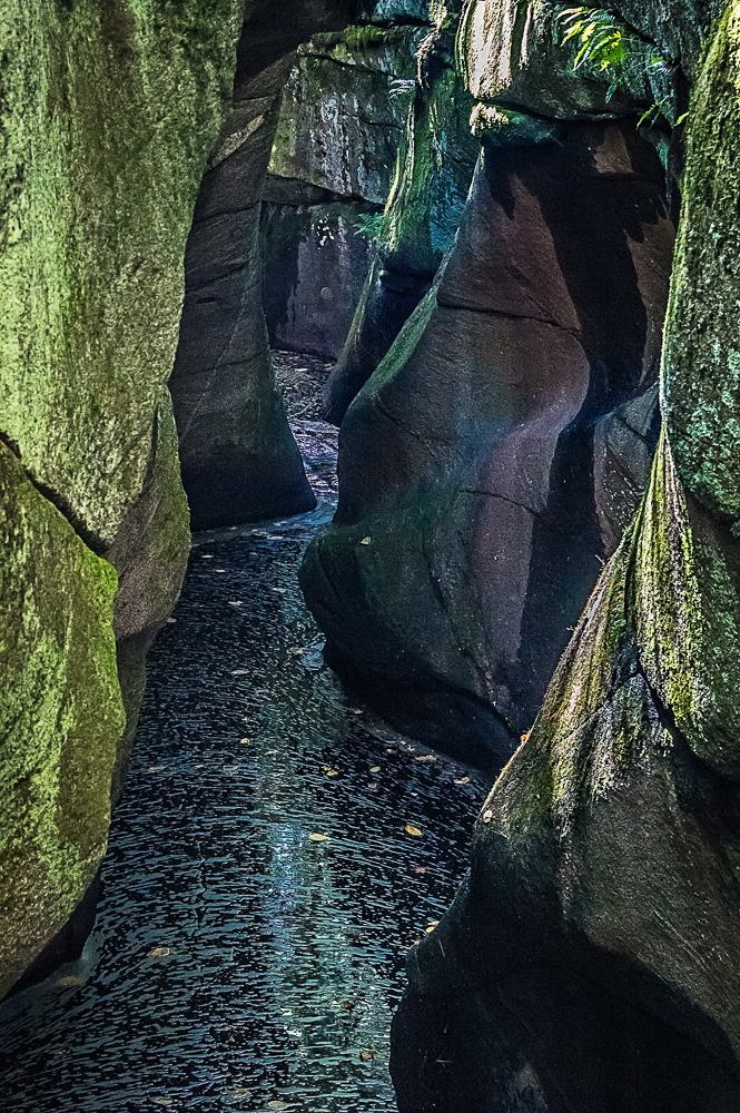
There is no way into the chasms on the upstream end where they begin and it didn’t look like it would be feasible to enter from downstream and walk up to the beginning. To get some photos of the chasms here I put my remote release onto my camera and mounted the camera on my tripod. I use a carbon fiber Sunpak Pro 423PX tripod with a pistol grip head when hiking. It’s light weight and does what I need. I extended one of the tripod legs and the center column to their fullest. I then found solid purchase on the edge of the chasm and holding the tripod upside down by the extended leg, I lowered my camera into the chasm. I then proceeded to use the remote trigger to take sample pictures, occasionally bringing the camera back up to review the sample shots so I could determine the correct exposure settings and decide the best focal length. After determining the best camera settings I lowered the camera back down and triggered more exposures while moving the camera left, right, up, and down to attempt a decent composition of the chasm. I know….. how could I compose if I couldn’t see through the camera? I was going by trial and error trying to keep note of the camera position while pulling the camera back up frequently to check the results. It would have been nice to have a tethered set up at this point, but I don’t like to carry that much gear when I hike. Does anyone know of a way to tether to an iPad? That would be awesome!
Down the Rabbit Hole
I headed downstream along the top of the chasms. There are two main chasms here. One on the edge of the river that doesn’t receive much water flow during lower water levels and one closer to the center of the river that runs pretty consistently no matter what the water level is. I concentrated on the edge chasm as I wouldn’t have to fight the current if I could get to the bottom. I reached the downstream end where the chasms emerge to feed a waterfall that dumps into a large pool of slower water. I was weighing my options and really, really didn’t want to walk upstream in the black pools at the bottom of the chasm. After some exploration I found a huge half moon shaped eroded hole on the edge of the chasm that had a hole in the rock at the bottom that looked large enough for me to squeeze through. After getting to the bottom of this hole I could see that it would give me access to a small ledge at the downstream end of one of the larger sections of the chasm. I unstrapped my camera backpack and wiggled through, dragging just my essential camera gear behind me. I imagine this entry is below water level during periods of higher water. Even at the bottom of the chasm I couldn’t see the bottom of the dark pool of water… still giving me the creeps. I had just enough room to set up my tripod and I could actually see what I was doing here, unlike the trial and error method from above. Here are the best results: